Thank You, Seattle City Council

Published at 09:20 on 22 May 2014

You’ve helped to cement my move out of your city that I made last year by helping to ensure that I won’t be moving back any time soon, thanks to making the sort of housing that would appeal to me illegal to build.

I’ve never really been able to understand this Seattle mindset that there’s basically only two types of housing that residents should be offered: large houses on large lots and apartments/condos crammed up against busy streets. And if you don’t want (or cannot afford) the former (what’s wrong with you, weirdo?), then you deserve the latter. It’s an attitude that befits a neurotic suburb, not a major city.

Oh well, good riddance.

It Was So Cold in Chicago! That Proves Global Warming is a Myth!

Published at 10:45 on 20 March 2014

No, it doesn’t.

First, Chicago is but one observing station, and last winter was but one season, what matters is what happens on a global scale, over time. As Robert Heinlein once quipped “Climate is what you expect, weather is what you get.” You’ll always have deviations from norms, that’s what weather is all about. What matters is the general trend of those deviations.

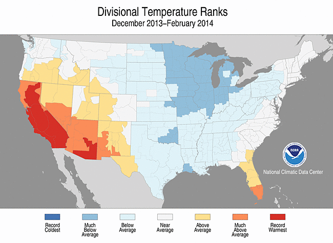
Second, as cold as last winter was in the Midwest, just in the USA alone the extremes of warmth were more profound:

tempsNote how most of California was the warmest on record. Despite having a very cold winter, none of the Midwest was the coldest on record.

NASA study: Radical Ecologists Have a Point

Published at 21:09 on 18 March 2014

That’s basically the executive summary of this article.

Particularly trenchant is the role that the authoritarian class hierarchy of civilization plays in helping to facilitate the collapse:

In both scenarios, Elite wealth monopolies mean that they are buffered from the most “detrimental effects of the environmental collapse until much later than the Commoners”, allowing them to “continue ‘business as usual’ despite the impending catastrophe.” The same mechanism, they argue, could explain how “historical collapses were allowed to occur by elites who appear to be oblivious to the catastrophic trajectory (most clearly apparent in the Roman and Mayan cases).”

And technology offers no quick fix:

Technological change can raise the efficiency of resource use, but it also tends to raise both per capita resource consumption and the scale of resource extraction, so that, absent policy effects, the increases in consumption often compensate for the increased efficiency of resource use.

Unfortunately, Us Tunnel Critics Told You So

Published at 10:49 on 12 February 2014

This is absolutely not a surprise.

Mark my words, the tunnel part of this project will end up costing somewhere in the neighborhood of $5 billion, i.e. about 2.5 times the official estimate. I’ve never committed this number to writing before, but it’s what I’ve long expected, based on the historical record of tunnel megaprojects going way over budget.

Da Klagwats aka Mount Pugh

Published at 18:51 on 9 September 2013

After an absence of about 20 years, I finally managed to re-visit Da Klagwats (aka Mt. Pugh) yesterday.

The mountain had been repeatedly and increasingly haunting my imagination in recent years. Was it really as spectacular as I had remembered? Even the names had acquired a haunting quality to them: Lake Metan, Stujack Pass.

In this on-line era, it’s easy to find accounts (such as this one and this one) which attest to the general correctness of those old memories. But those are but pixels on the screen, a poor substitute for being there.

A related factor is that the age clock is ticking. I’m 50 now, and I tire much more easily than when I was younger. If I kept pushing off returning to the mountain, eventually the day would come when I couldn’t return. So getting back there this year was one of the goals I set on my birthday last winter.

As before, the first test the mountain does on you is the one with your patience. It’s high enough that dry weather is critical. The weekend I had originally scheduled in August came and went (not only was it rainy in the mountains, I was still recovering from an illness and not back in peak shape yet). Every subsequent weekend was also rainy. All in all, not so different from 20 years ago, when it was late September when I finally summited Da Klagwats (late enough that it had been snowing the week before and I ran into melting snowbanks in the high country).

I took a leap of faith Saturday and loaded my truck with camping gear despite the thick overcast threatening to drizzle. All the weather forecasts had been predicting dry weather Sunday, and unlike some times, the forecasts had been very consistent instead of flip-flopping around. I camped near the trailhead so I could get an earlier start.

Amazingly, Sunday dawned mostly clear. Unfortunately, it wasn’t completely clear; the peaks were still shrouded in mists. However, the mists came and went, so I figured I’d at least get some peek-a-boo views from on top, and at that stage I had already spent enough effort getting to the area that it would be a pity to waste it.

The trail leaves from a low/mid elevation forest and persistently goes up, up, up. I made sure to pace myself because Pugh tests one’s endurance After an hour you come to small Lake Metan, which feels sort of like a halfway point. Hardly; at this point only 1,200 of the 5,300 vertical feet have been gained.

Onwards and upwards through old-growth forest the trail presses. The fall rains came early this year, so the forest floor was populated with multitudes of mushrooms. Took a picture of a few of them, but no time to dally, this is a hike with a goal in mind. Keep up a steady, moderate pace.

The forest seems to go on forever. The trail is on a south-facing slope, so the transitions to higher-altitude vegetation happen slower than they normally would. Eventually the spicy pungency of Alaska Yellow-Cedar is evident here and there, but despite that, the forest is still mostly of the huge old trees one sees at lower elevations.

Then, suddenly, the forest ends and one is at the base of a steep, open slope. Pikas are whistling. It’s a good place for a needed rest break. At this point, I’m a little over halfway up.

Press onward through switchbacks in the alpine sunshine now, zig-zagging up a steep slope between two sheer cliffs to the notch that is Stujack Pass. Lunch at the pass with a view of a snowfield below. It’s a spectacular place, rivaling most other hikeable summits.

But this is Pugh, and you ain’t seen nothing yet. At least that’s what my memory and the pictures I’ve seen online say, though it’s hard to believe both. Onward I press, with anticipation.

I am not disappointed in the least. It takes longer to reach the knife-edge ridge section than I remember; somehow the bonsai-filled meadow above the pass vanished from my memory. Maybe because I was faster back then and sped through that section, maybe because it pales compared to what follows.

And then it begins. Suddenly, you’re in a land of ice and bare rock. There’s a glacier below you on the north side of the ridge, and the sheer cliffs you saw from below on the south. The trail alternates between a narrow ledge above the glacier and the top of the ridge. Put away the hiking poles for now; hands are needed for scrambling.

It’s simply breathtaking. Views in every direction, and just like the first time it’s hard to believe one can get to such a place without technical climbing gear. But every time one gets to a spot where one is certain one has gone as far as one could go with mere hiking gear, an easy route onward and upward appears.

Past the head of the glacier, rocks shift to granite. Good; I remember granite at the top, it means I’m getting closer. More scrambling across bare rock, following the path from one cairn to another.

Ah, the summit meadow. I remember it getting easier near the top, and indeed it does. It’s still by any standards a very steep and rocky trail, but it’s a proper trail again. I check the altimeter: 6,900 feet, almost there.

The meadow is full of crowberry (Empetrum nigrum); this is the first place I saw that plant, and the only one I’ve seen it in so much abundance. It was good to see it again.

Mists come and go. Onward.

Tangles of old, rusting cable run across granite boulders. That means I’m basically there; the cables used to anchor a fire lookout. Sure enough, there’s the summit a few dozen feet ahead. Back again after 20 years.

Mists shroud both where I am and the nearby peaks, but I do manage to get a few good views of Glacier Peak during the times that both are clear. That settles it: when I return, I’ll be a 100% stickler for absolutely dry weather, even if it means postponing to the next season.

And then it was time to go down, down, down, down.

I normally eschew close-toed shoes and hike barefoot or in sandals, but the sheer amount of rugged downhill trail before me motivated me to don boots for the return trip. Despite the discomfort factor, I’m glad I did; I was much more steady on my feet in the steep spots (and there were many of them).

In the alpine zone, monitoring my overall progress was easy, because the landscape lay before me in plain sight. No such luck in the woods, but I had counted switchbacks on the way up (32 total before one hits the treeline), and counted backwards on the way down. Turns out I had missed a few on the way up, though, so the Lake Metan didn’t come into view through the trees when I expected it to. And then I missed a few going downhill below the lake, so I thought there were two more when I hit the final one.

Saw several obvious edible mushrooms (boletes, some young Hericiums, and one large chanterelle) on the way down, but collecting fungi wasn’t the purpose of this hike so I had nothing suitable to put them in. The exception was the chanterelle, which was only about 1/2 mile from the trailhead and thus easily survived being jostled around in my pack a bit. It went in tonight’s dinner.

As the sun was was slipping below the ridge, the road and my parked truck suddenly came into view. No need to break out the headlamp I had with me.

What an incredible place. Yes, it was every bit as magic and spectacular as I remembered it.

I’ll download the pictures I took soon.

Boletus edulis

Published at 07:58 on 4 September 2013

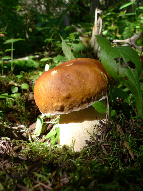
boletusWell, I’m 99.5% sure that’s what this is. The only remaining thing would have been to pick it, slice it, and see if it stained to a bluish color (if so, not edible). But I didn’t have any of my books or notes with me, and hadn’t reviewed them beforehand, not expecting to find any boletes on that hike.

A pity, because this one was in beautiful shape for collecting — big enough to be a good find, yet young enough to probably be free from fungus gnat maggots. However, it’s always better to miss out on a treat than it is to mistakenly eat something poisonous, and I know where I found it, so I have a spot to return to.


Highway 9 is Still Highway 9… Sort of… for Now

Published at 20:04 on 18 February 2013

Today I had a chance to drive on Highway 9 north of Arlington. The first time I drove that stretch of road, about 25 years ago, I was shocked at how quickly it changes character. Between Arlington and the Seattle suburbs, it was a wide, straight 2-lane highway with paved shoulders.

Past Arlington, it was like a different road altogether. The road abruptly became not much more than 20 feet wide as it started climbing into the foothills. The speed limit dropped from 55 to 35. Many curves were far slower than that. Bridges were typically wooden and single-laned. The traffic volume also dropped to practically nothing at about the point the road changed character.

Well, it’s still not as straight and fast there as it is south of Arlington, but it’s been widened to some degree; it’s probably more like 22 or 24 feet now. There’s been a depressing amount of suburban development in those hills (well, two subdivisions, but that alone is depressing considering how rural it used to be).

But there’s still a 10 mile stretch that’s as narrow and windy as it ever was, and I was floored when I discovered that the last of the one-lane bridges was still there. This time, I had to wait for traffic coming the other way (I don’t think I ever had to way back when; there was almost no traffic on that stretch then).

It’s not going to last, however. Not that I’m surprised.

What really frosts me is that the need for widening and straightening on that stretch of highway is driven by the suburbanization. The logging-road-with-a-layer-of-blacktop that was the old highway had plenty of extra capacity to handle the odd logging truck or weekend vacationer from the city. If the land had stayed rural, that old road would still have no trouble handling the little traffic using it.

Being a state highway, it is my taxes which are helping to pay for those upgrades. If the full cost was charged back to those moving to the remote subdivisions above Clear Lake, I doubt those subdivisions would have happened: the fees would have rendered them economically uncompetitive.

It puts the lie to the capitalist individualist rhetoric against growth management laws: even if you just focus on economics and ignore the environmental costs of sprawl, it’s not just a matter of a freely-chosen set of economic transactions between landowners, builders, and home-buyers. If those homes had been built up against existing developed land in Burlington or Arlington, it would have taken much less (dozens of miles less, in fact) road building to serve them, and the road-building would have been done mostly at the municipal level, paid for by local property taxes.

Investigating Bainbridge Island

Published at 21:18 on 19 January 2013

I spent the afternoon investigating another island alternative to Seattle, should my desire to telecommute from Bellingham for one reason or another not come to pass: Bainbridge Island.

It’s not as culturally compatible with what I desire as Vashon Island is, but all in all it is a far more practical location and could be a workable solution. Vashon’s sole town is in the center of the island, miles (and an arduous hill) from the nearest ferry landing, and that ferry goes not to Downtown Seattle but to one of Seattle’s outer neighborhoods, a significant bus ride from Downtown. There are a few foot ferries that run from Vashon Island to Downtown, but the key word is few: miss them, and you’ve gone from a little bit late to incredibly late.

Bainbridge Island, by contrast, has its sole town on the same harbor the ferry docks at, and every run of that ferry goes directly to the dock in Downtown Seattle. So I would be able to walk from my apartment or condo on the island to the ferry, and then walk from the ferry to my office Downtown. No worrying about missing the one or two useful ferry runs of the day, or about timing transfers from bus to boat.

Bainbridge, like Vashon, is a once-rural island that has turned mostly into exurban hobby farms. Thus, it still has the minus of not having any large and truly wild areas on-island. In Bainbridge’s case, however, that doesn’t matter so much, because the far side of the island is connected by a bridge to the Kitsap Peninsula, which in turn is connected by a bridge to the Olympic Peninsula. It ends up being possible to drive to some very nice hinterlands without having to compete for limited vehicle space on the ferries with all the other summer weekenders.

In fact, that limited vehicle space acts as a sort of limiting valve for how busy the Kitsap and Olympic peninsulas can get on summer weekends, meaning less crowds (and a very low chance of traffic congestion) for me.

So, a condo on Bainbridge could work for me. There’s no food co-op there, but the one grocery store on the island is one of those rare supermarkets which really does live up to its claim of having a full and comprehensive selection of organic and natural foods. (I’ve seen such things before on islands.) And there’s the basic selection of businesses any town of 10 or 20 thousand people would be expected to have (in addition to lots of upscale boutiques). I wouldn’t have to live a life revolving around a car for my daily routine.

But, Bainbridge is still very much part of the Seattle metro area. It’s easier access to nature (compared to the big city across the water) is a privilege rationed out on the basis of the ability to pay a significant premium; it’s one of the most expensive places to live in the Pacific Northwest.

I have a good job and no kids to support, so I could afford to live in an apartment or condo there. That’s not the issue. The issue is that a greater urban area which reserves basics like access to nature and a home in a quiet, unpolluted neighborhood so much according to socioeconomic class is not an urban area in keeping with my core values.

In Bellingham, by contrast, everyone lives a bicycle ride (not a drive in a car) away from large wild areas. The children of the poor and the working class can ride their bikes on the trail to Larrabee State Park as easily as the wealthy California retirees. There’s even a mobile home court which abuts a green space in Bellingham; housing close to nature is not strictly limited to the affluent, either.

So, Bainbridge would work as an alternative, but it’s very much a “Plan B” alternative. My primary desire involves shaking the dust of Seattle’s elitist class privilege from my feet.

Three Observations on the Issaquah Highlands

Published at 20:41 on 15 January 2013

They’re definitely trying to use land more efficiently than normal suburbia. There’s lots of townhomes and apartments there. There’s not always huge amounts of separation between differing land usage; it is possible to easily walk from some of the housing to some of the shops. A big chunk of the land was set aside as a wildland park (which was the main reason I was there, to go for a midwinter hike).

Particularly at its current stage, it’s still very much auto-oriented suburbia. It has its own freeway exit, and is served by a feeder road far wider than one would have in an older, traditional city for an equivalent-sized neighborhood. While there’s plans to build enough shops to make it self-sufficient, it’s not there yet: for example, there’s still no grocery store at all there; you must drive several miles to the nearest one. There’s big gaps in the still-incomplete development that beg to be driven across. Most of the housing is not at this time a convenient walk to shopping. Transit service, at this stage, is minimal.

It shows the limitations of capitalism. If you’re not affluent, all you can afford there is a condo or a townhome. If you’re well off, there’s detached homes (with views) available. There’s very large homes on large lots if you’re really rolling in the dough-re-mi. In other words, it’s not really repudiating the wasteful American lifestyle: it’s merely pricing the non-rich out of some aspects of it, turning it into more of an elite privilege than it presently is. (Which it definitely is, when you look at things on a world-wide scale.)