Not Much Smoke; Rain Coming

Published at 09:09 on 5 August 2021

First, my smoke warning was mostly a bust. Some smoke did make it down to ground level earlier this week, but it didn’t last very long and the air quality never got worse than the moderate range. So our incredible run of luck at avoiding the smoke continues. It does not look likely to get smoky again in the near future. I still will be surprised if we escape this summer without any serious episodes of degraded air quality at the surface, but who knows, we just might.

The best models do all agree that starting as soon as tomorrow, we are in for a spell of weather damper than we have seen since June. Some model runs are saying it will be quite damp; if so, this could end up really helping the situation with the fires in Okanogan County. But others are saying amounts should be fairly paltry (remember, there has been no more than a trace of rain since June, so the phrase “damper than we have seen since June” really doesn’t say much).

There is, in other words, far less model agreement on precipitation amount than on the general fact that at least some precipitation is coming. What this means is that it is really not possible for anyone to make an accurate forecast as to precipitation amount. Any amounts you see being forecast, even in professional forecasts, need to be taken with more than a few grains of salt. A given forecast might end up being correct, but if so it will be a matter of sheer luck.

This is in fact one of the biggest problems with weather forecasts as they are currently disseminated. There is no information given as to accuracy. (I actually had a pretty easy job with last winter’s successful snow forecasts; models were in significant agreement, and all I did was summarize them.) It would help a lot if the public had some idea of how confident forecasters were in a given forecast.

A Garden-Variety Heat Wave; Still No Smoke (for Now)

Published at 11:00 on 29 July 2021

We are now in the midst of a pretty garden-variety heat wave for Northwestern Washington. Temperatures in the eighties seem positively anticlimactic compared to readings that pushed the century mark in coastal areas and soared well above it even a short distance inland. It simply underscores how extreme the late June heat wave was. Things will be heading closer to seasonal norms by Sunday, with even the chance of a few showers on that day.

Regarding smoke, we continue to luck out. Fires began erupting shortly after the late June heat wave. At that time, I was pretty sure our luck would not hold for as long as it has. Even many areas east of the Cascades have often escaped the smoke; only the northern tier of such counties has been consistently smoky, as smoke from fires in Okanogan County streams due east.

On the subject of Okanogan County, I had been planning to do some volunteer botanical survey work there this week. The persistently awful air quality readings (generally somewhere between unhealthy and hazardous with little hope for immediate improvement), persuaded me to cancel.

Models indicate we should see some smoke aloft by late Saturday afternoon to early Sunday morning. The source of the smoke will actually be fires well to the south of us in California. This smoke is forecast to stay in the upper atmosphere, so while it may make skies look dingy, air quality near the surface will be unaffected. The clouds and showers forecast for Sunday may well make the dinginess harder to notice.

I will still be surprised if the smoke spares us for the entire rest of the dry season. I am going by pure odds here: chances are slim that low-level flow will remain as persistently in our favor for avoiding smoke as it has been. Sure, it could happen, but it probably won’t. It is still wise to be prepared.

Smoke Aloft

Published at 11:43 on 9 July 2021

Perhaps you have noticed it: the sky has a dingy aspect to it today, and sunlight is a little less intense and a little more yellowish than normal. The reason is smoke. There is wildfire smoke above us. It has not made it down to the surface due to the surface flow being onshore, so there have not been any real air quality concerns about it. (East of the Cascades, it is a different story; the smoke has made it down to the surface several times already there.)

This has happened once or twice before in the past week or two. Eventually, our luck will run out and the smoke will make it down to the surface. Although it is not known exactly when that will happen, it is early enough in the summer, with most of the dry season left to go, therefore it is almost certain to happen at some point. Hence my earlier warnings about preparing for smoke.

For this weekend, however, we should be safe. The smoke aloft is in fact modeled to depart by Sunday afternoon, so the sky should get clearer and bluer. Temperatures will be somewhat above long-term norms, but it will not be a heat wave by any measure. Highs should be in the mid-to-upper 70’s near the coast and into the low 80’s inland.

What we really need at this point is a summertime rain storm to reset the fire conditions, but nothing of the sort is modeled in the near future.

Three Days in Hell

Published at 10:49 on 1 July 2021

I knew a heat wave of the sort the Pacific Northwest just experienced was going to happen eventually, I just thought eventually would take a lot longer than the year 2021 to arrive. Yet here we are.

It started about a week out, when one of the weather forecasting models started predicting simply insane temperatures. Instead of being a blip, an outlier, the other main accurate model quickly came on board, and then both models stuck with that forecast as the time approached. It was both surreal and frightening. By the time the forecast was within three days, it was clear that it was going to happen, for the simple reason that I have never seen a time when the forecasting models were this consistent, both from model to model and run to run, and not seen the modeled forecast come true at that time frame.

And come true it did, with absolutely surreal high temperatures. Portland came close to reaching the all-time record high for Las Vegas, and Seattle got hotter than Atlanta ever has. Beyond the immediate human cost is the ecosystem cost: our forests simply were not evolved to deal with such conditions, and already there are many reports of widespread tree injury of death. At this early stage, it is difficult to tell injury from death, but even if it is the former, the latter probably will not be that far behind, because the summers here are already warmer and drier than long-term norms, so even less-dramatic conditions can logically be expected to continue stressing trees until many succumb.

I do not see much evidence of this in my immediate area, but this area had both higher dew points and lower temperatures than most parts of this region during the heat wave, so it is to be expected that the immediately observable effects would be less here. There are plenty of reports of more dramatic and noticeable tree damage in other parts of the region out there, and I have no real reason to doubt them.

There is little, if anything, that I love more than the native forests of this region, and the realization of their impending demise fills me with both grief and rage simultaneously. May the future have mercy on our souls.

Cliff Mass Lies Again

Published at 13:10 on 25 June 2021

In a recent post of his, he claims, regarding extreme heat waves:

There is no evidence that such a wave pattern is anything other than natural variability (I have done research on this issue and published in the peer-reviewed literature on this exact topic).

This is a recurring pattern with Mass: passing off a topic on which there is debate in the scientific community, as something that is settled, with his own personal opinion in the debate as the settled truth. Actually, there is some evidence of the sort Mass denies:

“This is a weather system that can be very persistent, it can last for many days,” said Dim Coumou, a researcher at the Potsdam Institute for Climate Impact Research. “It brings clear skies, very high temperature[s].”

While climate change has already warmed the planet about 1.2C since pre-industrial times, scientists such as Coumou believe it has also shifted atmospheric patterns.

His research shows that a gradual weakening of the jet stream during summer makes these high-pressure systems more persistent, resulting in longer heatwaves. The jet stream, a band of fast-moving wind high in the atmosphere, greatly influences weather patterns in the northern hemisphere

Source.

Edit: And his grasp of statistics is all wrong, too.

A Mostly Dry and Cool Weekend

Published at 09:12 on 30 April 2021

The official forecast for tomorrow, Saturday, is showery, but I just don’t see it; both of the top models are saying it should be dry. I also don’t see it being quite as warm as the official forecasts say. Those claim the high temperatures should flirt with the 60˚F mark, particularly on Sunday, but again, neither of the top models agrees with that; both are saying high temperatures should be solidly in the fifties.

I suppose I could be all wet here, because I don’t have quite the experience sanity-checking springtime modeled temperatures that I do for wintertime ones, and they may well be notorious for underestimating daytime solar warming now that sun angles are higher. But as of right now, the official forecast maxima just do not seem quite right to me.

So far as precipitation goes, I am quite confident that both Saturday and Sunday will be dry. Regarding clouds, it should for the most part be variably cloudy throughout the weekend.

Back to Rain Soon

Published at 07:27 on 23 April 2021

We sort of won the lottery last weekend: a completely sunny, warm one. In fact, if you are a sun-lover we won the lottery for nearly a fortnight.

Well, that “lucky” streak is about to end quite decisively. It is looking like the temperature on Saturday might struggle to reach the mid-fifties Fahrenheit. Quite a change from the “spring tease” we have recently been experiencing. Or more precisely, the rainy and chilly relapse is itself part of that tease.

Fire managers do not consider this recent warm and dry stretch to be good luck; it has done a frighteningly good job of drying things out. There was in fact a grass fire near Chilliwack last week, and there have already been red flag (i.e. extreme fire danger) warnings issued in Oregon.

While warm and dry spells are not unusual in April, this one has been astoundingly warm, and in particular it has been astoundingly dry. It is the low dew points that have done as much to dry things out as have the warm temperatures.

It is my feeling that the anomalous nature of this warm spell is probably related to global warming; however, that is only a hunch and it will take further data to establish the trend and settle the question.

Enemies of taking action on the climate crisis are fond of pointing such things out; however, it is critical to keep in mind that settling such questions and the issue of whether or not to take action now are two different matters. Although it is not possible to state the exact nature of the disruption that climate change will cause, it is still quite clear that odds are extremely high there will be significant disruption of some sort, thus common prudence dictates taking action so as to minimize those consequences.

It feels tedious to have to point the above out, but having to do so is simply a natural consequence of living in a political system badly divorced from obvious reality.

Anyhow, I hope everyone enjoyed how warm the last weekend was, because the coming one certainly will not be.

A Nearer Miss than Many May Realize

Published at 10:16 on 14 March 2021

On Thursday I said there was a chance of snow tonight into tomorrow morning (note the emphasis). At that time, it really looked as if the models might be converging on that forecast. But, it was still a ways out and they had not settled on lowland snow for very long, so I had my doubts.

Well, it’s not happening. My skepticism was borne out: the storm tracked further north, keeping the coldest air further north. The front also made landfall a bit earlier.

But we actually came fairly close to getting some lowland snow. Here is a capture from a highway cam near Port McNeill, BC (near sea level at the northern end of Vancouver Island) this morning. Pretty snowy.

Why They Don’t Release Raw Model Guidance to the Public

Published at 08:54 on 25 February 2021

This is called a meteogram:

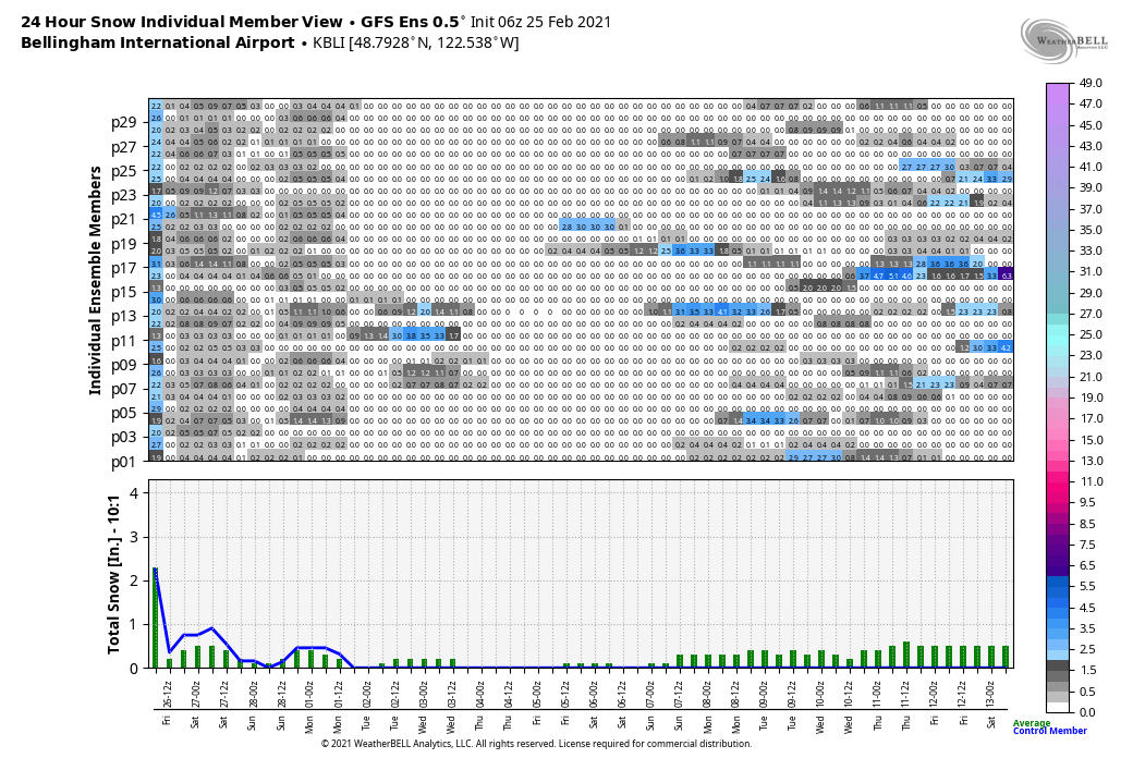
It is a graphical representation of a model run for a single point on the Earth’s surface, in this case the weather station at Bellingham airport. Note that I should have said “suite of model runs” instead of “model run:” each so-called forecasting model is in fact multiple runs, each initialized with a slightly different set of parameters, all based on current observations. This is done to provide a measure of how reliable the model is: if each run in the suite is all over the map (like they are for the weekend after next), it means the model’s predictions cannot be trusted very much.

By contrast, every run in the suite above is in agreement that we are about to have a lowland snow event, totaling an inch or two. Very high confidence, but wait. This is for the GFS model, the one developed by the National Oceanic and Atmospheric Administration. This model has a tendency in our climate to underestimate the moderating effects of the Pacific Ocean and the Cascade Mountains, plus it is generally not as reliable as the ECMWF model developed by the EU nations. What does that model have to say?

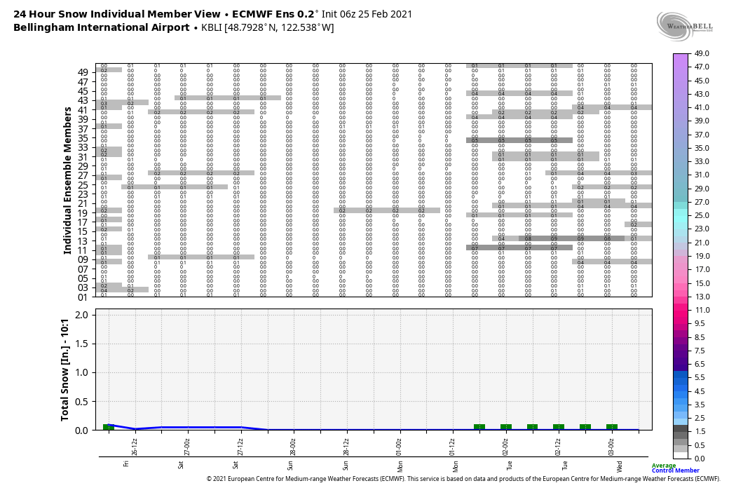
Both significantly less snowy and significantly less confident in any sort of snow outcome. Let me let you in on another secret: any time those models forecast a snowfall range in the lighter gray colors, one almost never sees any accumulation unless the temperature is solidly below freezing at the onset of the event. The temperature is not forecast to be solidly below freezing. In other words, this model is saying there is an off chance of seeing some wet flakes in the air tonight, with no accumulation.

Now, if the ECMWF model had shown basically the same story as the GFS one, we would be in a situation much like we were going into the solstice, and I would be making a confident snow prediction regardless of what the official forecasts said. If both models consistently tell the same story, they are almost always correct.

But both models are not consistently telling the same story, so what to do about it? First, what we can do is limited: it’s going to be a lower-confidence forecast, no matter what. The signs are mixed as to what is going to happen. However, the more accurate of the two models is saying little if any snow tonight. Moreover, the less accurate model is known to have defects which can explain precisely this discrepancy.

Therefore, it is wise to go with the ECMWF guidance: an off chance of some wet flakes in the air.

But note what would have happened if a) I liked snow, b) I didn’t know about the defects in the GFS model, and c) I let my emotions cloud my judgement. I would have helped start a false rumor about there being a viable chance for an inch or two of snow overnight.

This is why the models are often called model guidance: they are not there to forecast the weather, they are merely there to help people forecast the weather.

Damp on Saturday, Wet on Sunday

Published at 19:38 on 19 February 2021

That is both my forecast and the official forecast. On the subject of the official forecasts, they are usually pretty good, and usually the same forecast I would give, were I a professional weather forecaster. The times I make a big stink are the times the official forecasts don’t make much sense to me.

Anyhow, if you’re planning outdoor activities, Saturday definitely sounds like the better day. The source of the moisture that will make Sunday (and the beginning of the work week) so wet is coming out of the tropical Pacific, so it will drag some relatively warmer air up our way with it. Expect some high temperatures in the fifties, maybe well into the fifties (Bellingham is often one of the warmest spots in Western Washington when a strong south wind is blowing, more on why that is the case sometime later).

That means snow levels will be rising, though at this time it seems likely they will stay (just) below the elevation of the Heather Meadows area. Still, if I were skiing, I would opt for Saturday. Some light snow which is drier because temperatures are still reliably below freezing sounds a lot nicer than copious amounts of heavy, wet “Cascade concrete” snow.

This will likely prove to be just a temporary mild interlude to a generally cool pattern that we are for the next several weeks. The long-range models have all been consistent with things staying on the cool side at least through the first half or March.

This also means that we’re not out of the woods quite yet when it comes to lowland snow; yes we can get lowland snow in March, sometimes significant amounts of it. I must emphasize, however, that at this time there is no specific indication of any such thing. The dice are merely loaded so that outcome has a higher chance than normal, that is all.