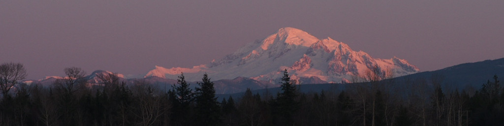
Da Klagwats aka Mount Pugh
Published at 18:51 on 9 September 2013
After an absence of about 20 years, I finally managed to re-visit Da Klagwats (aka Mt. Pugh) yesterday.
The mountain had been repeatedly and increasingly haunting my imagination in recent years. Was it really as spectacular as I had remembered? Even the names had acquired a haunting quality to them: Lake Metan, Stujack Pass.
In this on-line era, it’s easy to find accounts (such as this one and this one) which attest to the general correctness of those old memories. But those are but pixels on the screen, a poor substitute for being there.
A related factor is that the age clock is ticking. I’m 50 now, and I tire much more easily than when I was younger. If I kept pushing off returning to the mountain, eventually the day would come when I couldn’t return. So getting back there this year was one of the goals I set on my birthday last winter.
As before, the first test the mountain does on you is the one with your patience. It’s high enough that dry weather is critical. The weekend I had originally scheduled in August came and went (not only was it rainy in the mountains, I was still recovering from an illness and not back in peak shape yet). Every subsequent weekend was also rainy. All in all, not so different from 20 years ago, when it was late September when I finally summited Da Klagwats (late enough that it had been snowing the week before and I ran into melting snowbanks in the high country).
I took a leap of faith Saturday and loaded my truck with camping gear despite the thick overcast threatening to drizzle. All the weather forecasts had been predicting dry weather Sunday, and unlike some times, the forecasts had been very consistent instead of flip-flopping around. I camped near the trailhead so I could get an earlier start.
Amazingly, Sunday dawned mostly clear. Unfortunately, it wasn’t completely clear; the peaks were still shrouded in mists. However, the mists came and went, so I figured I’d at least get some peek-a-boo views from on top, and at that stage I had already spent enough effort getting to the area that it would be a pity to waste it.
The trail leaves from a low/mid elevation forest and persistently goes up, up, up. I made sure to pace myself because Pugh tests one’s endurance After an hour you come to small Lake Metan, which feels sort of like a halfway point. Hardly; at this point only 1,200 of the 5,300 vertical feet have been gained.
Onwards and upwards through old-growth forest the trail presses. The fall rains came early this year, so the forest floor was populated with multitudes of mushrooms. Took a picture of a few of them, but no time to dally, this is a hike with a goal in mind. Keep up a steady, moderate pace.
The forest seems to go on forever. The trail is on a south-facing slope, so the transitions to higher-altitude vegetation happen slower than they normally would. Eventually the spicy pungency of Alaska Yellow-Cedar is evident here and there, but despite that, the forest is still mostly of the huge old trees one sees at lower elevations.
Then, suddenly, the forest ends and one is at the base of a steep, open slope. Pikas are whistling. It’s a good place for a needed rest break. At this point, I’m a little over halfway up.
Press onward through switchbacks in the alpine sunshine now, zig-zagging up a steep slope between two sheer cliffs to the notch that is Stujack Pass. Lunch at the pass with a view of a snowfield below. It’s a spectacular place, rivaling most other hikeable summits.
But this is Pugh, and you ain’t seen nothing yet. At least that’s what my memory and the pictures I’ve seen online say, though it’s hard to believe both. Onward I press, with anticipation.
I am not disappointed in the least. It takes longer to reach the knife-edge ridge section than I remember; somehow the bonsai-filled meadow above the pass vanished from my memory. Maybe because I was faster back then and sped through that section, maybe because it pales compared to what follows.
And then it begins. Suddenly, you’re in a land of ice and bare rock. There’s a glacier below you on the north side of the ridge, and the sheer cliffs you saw from below on the south. The trail alternates between a narrow ledge above the glacier and the top of the ridge. Put away the hiking poles for now; hands are needed for scrambling.
It’s simply breathtaking. Views in every direction, and just like the first time it’s hard to believe one can get to such a place without technical climbing gear. But every time one gets to a spot where one is certain one has gone as far as one could go with mere hiking gear, an easy route onward and upward appears.
Past the head of the glacier, rocks shift to granite. Good; I remember granite at the top, it means I’m getting closer. More scrambling across bare rock, following the path from one cairn to another.
Ah, the summit meadow. I remember it getting easier near the top, and indeed it does. It’s still by any standards a very steep and rocky trail, but it’s a proper trail again. I check the altimeter: 6,900 feet, almost there.
The meadow is full of crowberry (Empetrum nigrum); this is the first place I saw that plant, and the only one I’ve seen it in so much abundance. It was good to see it again.
Mists come and go. Onward.
Tangles of old, rusting cable run across granite boulders. That means I’m basically there; the cables used to anchor a fire lookout. Sure enough, there’s the summit a few dozen feet ahead. Back again after 20 years.
Mists shroud both where I am and the nearby peaks, but I do manage to get a few good views of Glacier Peak during the times that both are clear. That settles it: when I return, I’ll be a 100% stickler for absolutely dry weather, even if it means postponing to the next season.
And then it was time to go down, down, down, down.
I normally eschew close-toed shoes and hike barefoot or in sandals, but the sheer amount of rugged downhill trail before me motivated me to don boots for the return trip. Despite the discomfort factor, I’m glad I did; I was much more steady on my feet in the steep spots (and there were many of them).
In the alpine zone, monitoring my overall progress was easy, because the landscape lay before me in plain sight. No such luck in the woods, but I had counted switchbacks on the way up (32 total before one hits the treeline), and counted backwards on the way down. Turns out I had missed a few on the way up, though, so the Lake Metan didn’t come into view through the trees when I expected it to. And then I missed a few going downhill below the lake, so I thought there were two more when I hit the final one.
Saw several obvious edible mushrooms (boletes, some young Hericiums, and one large chanterelle) on the way down, but collecting fungi wasn’t the purpose of this hike so I had nothing suitable to put them in. The exception was the chanterelle, which was only about 1/2 mile from the trailhead and thus easily survived being jostled around in my pack a bit. It went in tonight’s dinner.
As the sun was was slipping below the ridge, the road and my parked truck suddenly came into view. No need to break out the headlamp I had with me.
What an incredible place. Yes, it was every bit as magic and spectacular as I remembered it.
I’ll download the pictures I took soon.